
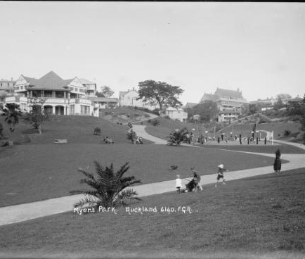
Myers Park
AUCKLAND'S HIDDEN TREASURE
The Waihorotiu
The Myers Park gully is the watershed area at the head of the
Horotiu Stream or Queen Street River as it was often called. This stream had carved out the valley over six million years ago as part of the great Waitemata River system. The mouth of that enormous river had emptied into the Pacific beyond Great Barrier Island. When the ocean levels rose at the end of the last Ice Age (15,000 years ago) the Waitemata river valley was flooded, creating the Hauraki Gulf and Waitemata Harbour around 7,000 years ago.
Auckland: the tide goes out. The Tamaki River, Grafton Gulley stream and Queen Street valley are all surviving tributaries of that ancient river system.
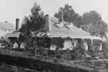
Around 1845 (or thereabouts) a stone house was completed on the Karangahape ridge. It looked down the valley which had been created by the stream - the same valley in which Myers Park was created in 1913-1915.
The house was owned by the jewish merchant David Nathan - its story is told here:
Scoria House. This residence had a view to the north of the fledgling town of Auckland (which at that time extended no further than about Victoria Street).
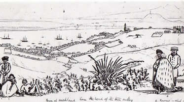
Looking north from the Karangahape ridge down the Waihorotiu gulley in the early 1840s
Auckland in the 1840s
Below the house the small stream gurgled down the gully (at least in wet weather).
At the bottom of the hill it drained into a marshy area (the current site of Aotea Square and the Civic Theatre) which was fed by other tributaries; the Wellesley and Wakefield Street streams and a branch from Vincent Street.
From this point it continued on its way to the harbour - Queen Street follows the lower course of the stream which is why it has a couple of slight twists and turns along it's route.
.ving a stream in the middle of the road was inconvenient to say the least. In the absence of any proper drains or sewers it became stagnant with all sorts of waste especially run off from the adjacent roads.
Although about 90% of the population walked everywhere there were considerable numbers of horses used for transportation either being ridden or pulling carts and carriages.
On average, horses defecate about 14 times a day and, consuming about 11 litres of water a day, release the same amount of urine.
Combined with wandering stock, dogs, the lack of public toilets (and a municipal rubbish collection) the streets of 19th century cities were extremely dirty.
Most of this waste inevitably ended up in the stream in the centre of the road, which, by the time it reached the foreshore at Fot Street was probably little better than an open sewer.
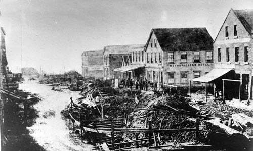
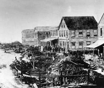
The Ligar Canel at Fort Street in the 1860s
Wooden walkways had to constructed across it and certain portions completely boarded over with platforms. These were subject to rotting however and as the banks were constantly crumbling people and sometimes even carriages tumbled in.
During his comparatively short time in Auckland, the City Council Engineer, Mr Ligar made a concerted effort to create reinforced wooden retaining walls along the exposed reaches of the stream.
The public began refering to it by his name, calling it the "Ligar Canal".
Charles Ligar (1811–1881) had been born in Ceylon, he was educated in Britain and was employed on the Ordnance Survey of Ireland until 1840. In 1839 he married the granddaughter of the Earl of Charlemont, Grace Hanyngton of Tyrone, Ireland.
Ligar was appointed Surveyor General of New Zealand by Lord John Russell and after being shipwrecked at the Cape of Good Hope, arrived in Wellington, New Zealand on 8 December 1841. He was also Land Titles Commissioner in the late 1840s.
As a colonel and commandant of the New Zealand Militia, he took part in the war at the Bay of Islands. He was involved in farming in Otago.
In 1845 he was apparently involved in designing additional fortifications for Auckland - Fort Ligar was created on the Hobson Street ridge as a subsidery to Fort Britomart and the Albert Barracks: it was probably little more than earth ramparts with small make shift huts - long forgotten traces of it were exposed when the Skytower was built on the site in the 1990s. Fort Ligar.
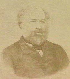
Charles Whybrow Ligar (1811-1881), by unknown photographer, c1859
La Trobe Picture Collection, State Library of Victoria, H8065
.
In 1856 he resigned from the New Zealand civil service, having discovering gold in the
Mataura River while searching for grazing land.
Ligar was appointed Surveyor General of Victoria in 1858. He invested heavily in livestock and with Hugh Glass, R. S. H. Anderson and John O'Shanassy as his partners Ligar leased three million acres (1,214,070 ha).
He was always unpopular in the Lands Department and, because his promises to reduce expenditure and speedily complete the surveys of the State of Victoria were not fulfilled by 1869, prominent politicians demanded his removal.
He resigned from his Government post in September 1869.
He then returned to New Zealand, apparently taking up the post of City Engineer for Auckland (administered at this time by a Board of Commissioners as it did not become a Borough Council until 1871).
Interestingly neither of his boigraphical entries mention the Auckland position at all - either Wikipedia or the Australian Dictionary of Biography.
During his time in Auckland he married an Auckland woman, Marie Williams, daughter of the late Captain Williams (his first wife had died in April 1868).
Soon after struggling with the Queen Street River Charles Wyhbrow Ligar retired to Europe on an Australian government pension of £500 a year.
The Ligars lived on the Mediterranean coast for some years before taking up a ranch in Texas. He died in February 1881 and was buried at Willow Springs, Parker County.
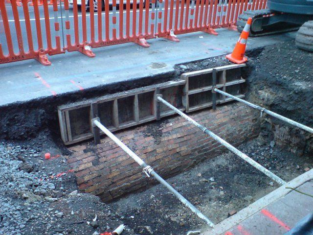
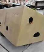
The bricked up stream/drain exposed recently during repairs to Queen Street. https://en.wikipedia.org/wiki/Waihorotiu_Stream
Eventually in the 1870s it was covered over as part the system of brick sewers and drains which were developing in the centre of town.
The Queen Street “River" still discharges into the harbour under the Ferry Building. It is now just a bricked in drain but it started life as a country stream.
There was film made recently about the Waihorotui and it's taniwha although some of the material on it's site is uneven in quality. http://waihorotiu.tumblr.com/
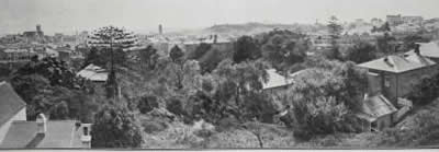
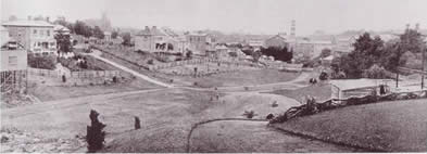
The overgrown Gully in 1912
The Overgrown Gully
Between the 1850s and the 1890s many buildings were built on the north facing slopes below the Karangahape Road ridge.
Liverpool, Vincent and Grey Streets and the upper part of Queen Street were lined with hundreds of wooden Victorian buildings, mostly houses, much like Grey Lynn still is today.
The houses and shops on Queen Street and Grey Street backed on to the gulley; each property having its own outhouse, garden, chicken run and rubbish heap.
The sections tended to be be rather long and narrow, becoming very steep right at the back where they backed onto the stream.
The back of each property tended to become quite overgrown with a variety of weeds and self sown trees. Areas such as these were used as dumping grounds for all sorts of rubbish.
Into the stream drained water from the gardens, rubbish heaps and outdoor toilets, undoubtedly tainting the water.
Through this morass of weeds, rats and rubbish ran the route of the choked stream before it disappeared underground at the bottom of the hill.
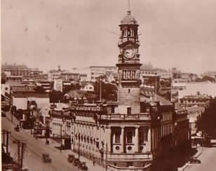
The new Town Hall with a glimpse of the gulley behind
The New Town Hall
Between the founding of Auckland in 1840 and the creation of the Park in 1913 the area saw over seventy years of human occupation - the build-up of refuse and overgrowth in the gulley was probably considerable.
The area to the south of Wellesley Street was not considered a particulary desirable area to live in. The very rich lived near Government House in Waterloo Quadrant while the developing suburbs of Parnell, Grafton and Ponsonby tended to attract the middle classes.
By the end of the 19th century only the poor ended up living in an area like Upper Queen Street, Grey Street or Vincent Street. It developed quite a lurid reputation as a centre of crime.
Grey Street in particular was regarded as a problem area for prostitution, illegal gambling and drug use such as Opium Dens.
Most of the houses were in very bad condition and were widely considered (probably correctly) as being slums - a source of biological as well as moral harm.
Arthur Myers MP
Arthur Myers, Mayor 1905-1910 (photo missing)
In 1911 the splendid new Town Hall was opened on the corner of Queen and Grey Streets, just below the gulley and just near where the stream went underground.
One of the major movers behind this project had been Arthur Mielzinier Myers, who was mayor from 1905-1910. In 1909 Myers laid the foundation stone for the new building.
Quite apart from the threat of raw sewage seeping under the new Town Hall it was certainly a distressing sight to see the barefooted children of the area playing in the rubbish filled gulley & stream.
A contemporary description called it an area of “slum shanties and rubbish tips", although most of the area was actually just overgrown wasteland with comparatively few structures.
Having been closely involved with the planning and construction of the Town Hall, Myers cannot have been unaware of the unhygienic state of the gully, but it was after 1910 when he was an MP that he turned his attention to dealing with it.
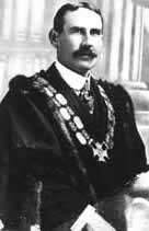
Christopher Parr, Mayor 1911 to 1915
The City Beautiful
The City Beautiful Movement was a reform philosophy of architecture and urban planning that flourished during the 1890s and 1900s with the intent of improving cities, mostly through monumental buildings and elegant parks.
The influence of the movement can be seen in Auckland by the appearance of several public facilities such as Victoria Park in 1905, Grafton Bridge in 1910, the new Town Hall in 1911 and the Tepid Baths in 1914.
In 1913 the then Mayor C.J. Parr initiated a programme of improvements for the City of Auckland, which amongst other things included the provision of new public parks.
This would result in the creation of several suburban parks such as Point Erin Park in 1911 and Parnell Park in 1913.
However these parks were fairly easy to create as they mostly included existing gardens or farmland, and often the land was fairly cheap to purchase.
The inner city location of the Grey Street gully needed special handling as the land would be expensive, but conversely require more landscaping.
The expense of the project would not be attractive to the ratepayers of the City of Auckland.
Parr approached Myers who donated £10,000 towards purchasing land in the area between Queen Street and Grey Street. In 1913 £10,000 was a substantial amount of money - possibly equivalent to $10 million today.
For the most part the City Council compulsorily purchased the back parts of properties along Queen and Grey Streets (although a small number of property owners actually donated land - they realised the value of their remaining property would be increased by the presence of the park).
Over the subsequent years the land was cleared and levelled - this meant removing a great deal of vegetation but also a surprising amount of domestic and industrial rubbish.
Over 40 tonnes of rotting leather was removed at the lower end of the site - obviously the off cuts from some long disappeared business on Queen or Grey Street.
Conversely extra clean soil was carted onto the site. The landscape radically changed as tons of earth was dumped in the ravine over the bricked in stream making the once steep sided gully into a comparatively quite shallow basin.
This means the ancient stream is probably located several metres below the current ground level.
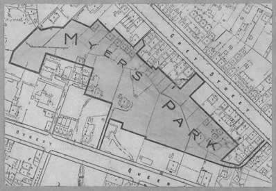
The Park in 1913: the winding line up the centre of the map is the route of the old stream
The Grey Street Park
Initially the park extended over six acres of land (extra areas were added in the 1920s and 1940s to make a total of eight acres.)
The site was actually chosen because it was comparatively empty - only 14 buildings, most of them very small, occupied the six acre site. (Thus the gully was not exactly the packed slum as it was represented in contemporary news reports).
The fact that 13 of the buildings were sold for removal suggests they were probably not decaying hovels either.
The one remaining house was converted into a caretakers cottage and still stands on the hill to the south of the new Kindergarten building.
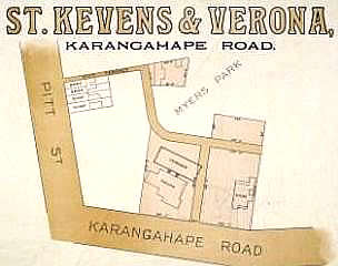
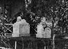
Sale of St Kevins House
The Entrance from K' Road
At the southern end of the site was the Nathan property - called Saint Kevins. This was located between the proposed park and the busy shopping throughfare of Karangahape Road.
The Nathans had been contemplating selling their K Road property for some time; the house was increasingly hemmed in by retail buildings and the noise from the increased traffic on the street was probably quite annoying.
Just before they sold the house in 1918 they decided to contribute to the "Grey Street Park" project by donating land to provide access from Karangahape Road..
In 1916 the Nathan family gave a 20ft right of way along the eastern boundary of their St.Kevins property to serve as the entrance to Myers Park from the south.
Their house, St Kevins, was demolished around 1920 and as a result of their gift part of the site was redeveloped as St Kevin's Arcade in 1924, which is still the entrance to the Park from Karangahape Road.
The newly cleared site circa 1914
The Newly laid out park
In early photographs the park looks like a plain, almost bleak bit of land with the most dominant feature the large expanses of municipal asphalt paving.
The cleared landscape was mostly an undulating lawn with a number of newly planted trees, which being mostly small saplings give little hint of the intended colourful landscape intended by the Park's designer Thomas Pearson.
Pearson decided that few of the plants in the gully were worth retaining - in the end only about eight trees were incorporated into the new design either because of their age, size or rarity.
The Playground & Kindergarten
At the time the Park was laid out a great many working class families lived in the area. As it was intended primarily as a safe place for children to play in, one of the most dominant aspects of the park was the well equipped playground.
Special equipment for childrens playgrounds was a very new idea at this time and was apparently developed by the New York City Parks Department.
Following the example of the Department Store owner John Court who had fitted out Victoria Park with playground equipment in 1912 Arthur Myers paid for the Playground equipment and arranged for it to be imported from America.
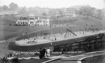
The Playground circa 1916
Myers Park, with its playground and Kindergarten is a text book example of the 'Reform Park' movement current at the time in North America.
This concept developed in the United States where rampant urban growth was raising many concerns and resulting in the systematic provision of safe spaces for children to play and green spaces to relax in.
The idea of 'organised play' was part of the 'progressive' educational attitudes prevalent at the turn of the 20th century. Families were not expected to amuse themselves as a group - children in particular were encouraged to socialise in their own age group.
Each age and sex was assumed to have special needs and the design of public parks reflected this; in particular, the needs of very young children were taken into account.
Playgrounds of this period often have duplicate equipment for different age groups, graduated in size - the Myers Park Playground is typical in this way.
Likewise it provided twinned sets of some items so children could play along side each other but differentiated by gender.
The Myers Kindergarten Building circa 1916.
Play Schools and Kindergartens date from the middle of the 19th century but became more common around this time including Public facilities subsidised by local authorities.
Myers had followed up his initial gift of money to purchase the land with more money to import Playground equipment.
He now donated another amount of money to design and build a kindergarten facility, the result of which is the splendid Arts & Crafts styled Kindergarten Building by Chilwell & Trevithick.
It is likely that the total amount of money Myers spent on the Park project was around £20,000. This was a very large amount at the time - possibly equivalent to $20 million today.
The Kindergarten building
The building was designed to be as modern and as safe a structure as possible - being built of reinforced concrete, steel and brick with a Marsaille Tile roof it was solid and fire proof.
The casement windows were made of metal, obviously very modern, but liable to neither rot, nor slide down on children's fingers as the typical Sash windows of the period were apt to do.
Although the building resembles a Tudor cottage it has no chimneys - possibly a deliberate visual indication that it is heated by electricity - again very modern and safe.
As well as being lit by electricity the interiors are flooded with natural light by the impressively large windows - again a very modern concept - it was a recent discovery of the disinfecting nature of sunlight and progressive architects tried to allow as much sunlight penetration into their buildings as possible.
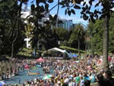
- Opera in Myers Park 2011
- Concert in the Park 2009
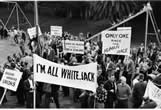
- Marti Friedlander Myers Park Protest 1960
See more past events further down.
Myers Park Sculptures
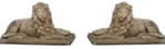
Stone Lions
In 1922 the Nathan Family offered a pair of Stone Lions to be used as entrance features for the new park. These had stood outside St Kevens House since the 1840s when Sir George Grey had used the house as Government House. They may have been the first European Sculptures brought to New Zealand - it is possible they came out from Britain but more likely they were created in Australia.
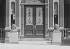
St Kevens with Lions 1840s
Myers Park was intended by its creators as primarily a children's realm with the emphasis on natural plants and sunshine. For this reason artworks were not a priority and may even have been seen as working against the aesthetic and moral intent of the park.
This may have been why the Lions were rejected in 1922.
Stone Lions at front door
However the terms of the gift may have been a contributing factor. The Nathans apparently stipulated that the statues be located at the Karangahape Road entrance to the Park, but by 1922 that site was not actually public land. The right-of-way gifted by the Nathans in 1918 meant the building constructed on that site needed to allow access from the street to the park (as indeed St Kevins Arcade does). The legal complications of Council imposing the statues on the new property owners were probably too great. In any event they were not installed and their subsequent fate is unknown.
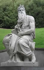
Moses, 1971
The statue of Moses was the first sculpture to be installed in Myers Park - that happened in 1973. In 1971 the Milne & Choyce Department Store celebrated the Centenary of the firm - part of the decorations of the Queen Street store had been two marble statues imported from Italy.
Both were full scale copies in marble of the work of Michelangelo Buonarroti 1475-1564, being his famous David and Moses.
They were made from marble from the same quarry as the originals.
After the celebrations the statues were offered to the City of Auckland, but neither the Art Gallery nor the Museum were interested.
The City declined the Statue of David but accepted the Moses and installed it in Myers Park at the base of the stairs leading from St Kevins Arcade.
For an explanation of the symbolism of the Moses please see this entry. Moses
Hau te Kapaka “The Flapping Wind"
In 2011 the first two of three bronze items by Rachel Walters were installed at the Queen Street entrance to the park. Hau te Kapaka “The Flapping Wind" comments on the effects of pollution and human activity on the natural world and wildlife. Their small scale and humour are specifically intended to attract the engagement of children. The third piece was installed in 2013.
- Oystercatchers hiding under a Banana Box on Queen Street. Oystercatcher - Haematopus unicolor
- Kokako on bollard with a paper bag over its head. Kokako - Passerformes callaeidae
- Pateke (brown teal) on Manhole cover with Bubble bag (near gateway). Brown Teal - Anas chlorotis
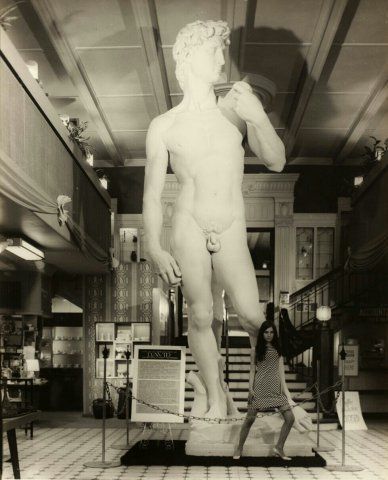
David in Milne & Choyce's store on Queen Street in 1971
The city declined to accept this sculpture and what happened to it is unclear. These sculptures evoke the 'Refined Good Taste' of the 19th century when the Italian Renaissance was very popular. In order to show they appreciated "good art" many people displayed reduced copies of sculptures such as this in their parlours. It also is representative of the renewed interest in Michaelangelo's work in the period following the Second World War.
In 1961 The Agony and the Ecstasy by Irving Stone was published - this was a biographical novel of the life of Michelangelo Buonarroti and became one of the most popular books of the period.
In 1965 the novel was made into a major motion picture; The Agony and the Ecstasy, starring Charlton Heston as Michelangelo and Rex Harrison as Pope Julius II. These were undoubtedly contributing reasons as to why the Florentine Sculpture Yard started to create full scale copies of Michelangelo's major works. Apparently three pairs were created in 1966: one pair stayed at the Statue Factory in Florence, one pair was sold to Forest Lawn Cemetery in Los Angeles and the third pair was purchased by Milne & Choyce of Auckland.
In November 1969 a poster showing the statue of David on display in a Bookshop in Sydney was seized by officers of the Vice Squad and the owner threated with charges until the Director of the New South Wales Art Gallery managed to intervene. In January 1970 a photograph of the David was part of another prosecution for selling indecent publications in the same city.
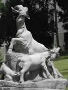
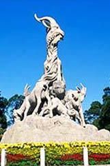
Five Goats, 1999
In 1999 Auckland's sister city Guangzhou presented the City with a granite statuary group of Five Goats. Guangzhou [Canton] is known as the Five Goats City. The Myers Park Statue is a reduced copy of the the sculpture located in the west part of Yiexiu Park in central Guangzhou, the original was erected in 1959.
Five Goats Yiexiu Park, Guangzhou
Auckland became a sister city with Guangzhou on February 17th, 1989
The placement of the granite group in Myers Park recalls the longstanding presence of the Chinese in the area, although it does not specifically commemorate the connection.
For the first half of the 20th century there were a number of Chinese living and working in the Greys Avenue / Cook Street / Hobson Street areas.
The group is symbolic of the contribution of the Chinese Community to New Zealand since 1864 and it is made of chinese granite to underline the enduring quality of this work.
It is a representation of a traditional Chinese story;
'A herd of goats discover a bleak valley and survive eating the rough vegetation. Their feeding prunes the spiny plants and their droppings manure the soil. Contained in their droppings are the seeds of plants from outside the valley. Over a period of time the valley is transformed into a fertile place due to their quiet diligent activity.'
Prior to the Communist Revolution in 1949 all chinese immigrating to New Zealand came from the Guangdong province directly to the north of the cities of Hong Kong & Canton.
Guangzhou is often referred to as “The Five Goats City". Legend has it that 5 celestial beings brought 5 goats into Guangzhou.
The goats were all carrying rice, which symbolized that they would make sure that the area would always be free of famine.
Past events in Myers Park
- Myers Park Medley
- Fun in Myers Park -
Myers Park, Thu 31 Dec 2015 – Thu 7 Jan 2016
- Myers Park Centennial Celebration - Myers Park, Sun 15 Feb 2015
- Neighbours Day - Grow in the City -
Myers Park, Sat 29 Mar 2014
- Spit It Out -
Myers Park, Thu 21 Feb 2013 – Thu 7 Mar 2013
- Fringe in the Park -
Myers Park, Sat 16 Feb 2013
- Celery Stories -
Myers Park, Fri 22 Feb 2013 – Sat 23 Feb 2013
- Amped in the Park - Myers Park, Fri 9 Sep 2011 – Sun 23 Oct 2011
- You & The Guerrilla Poets Join 100 Thousand Poets for Change -
Myers Park, Sat 24 Sep 2011
- The Sixth Plinth -
Myers Park, Sun 3 Apr 2011
- The Sixth Plinth - Myers Park, Sun 27 Mar 2011
- Soul Sessions -
Myers Park, Sat 5 Mar 2011
- When Animals Dream of Sheep -
Myers Park, Wed 23 Feb 2011 – Sun 27 Feb 2011
- Fringe In The Park -
Myers Park, Sat 26 Feb 2011
- Authentic Aikijujitsu -
Myers Park, Sat 12 Jun 2010 – Sat 26 Jun 2010
- Free Salsa in Myers Park - Myers Park, Thu 25 Feb 2010 – Thu 25 Mar 2010
- Authentic Aiki Jujitsu: CANCELLED - Myers Park, Tue 12 Jan 2010 – Tue 23 Feb 2010
- Planet A - March and Concert For The Climate - Myers Park, Sat 5 Dec 2009
- J Day (Auckland) - Myers Park, Sat 3 May 2008
Historical landmarks of Karangahape Road...
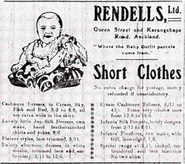
Rendell's Department Store
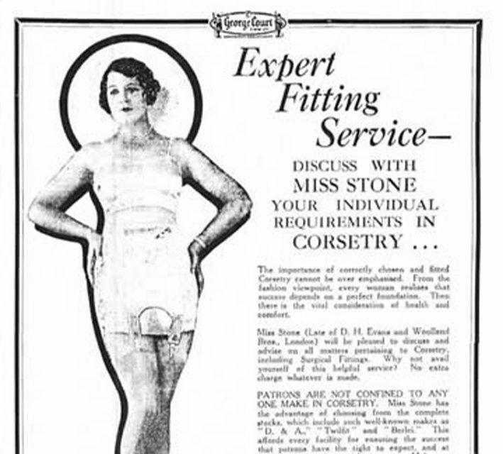
George Court's Dept. Store
Cinemas
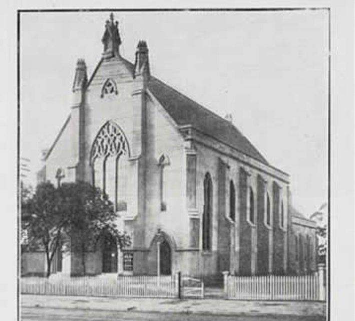
Pitt St. Church
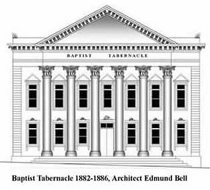
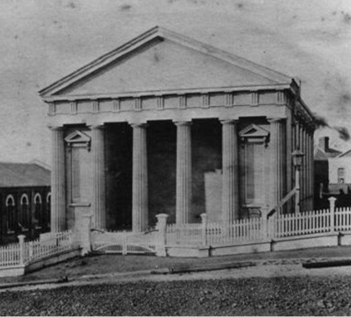
Baptist Tabernacle
Hopetoun Alpha
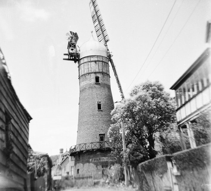
Partingtons Mill
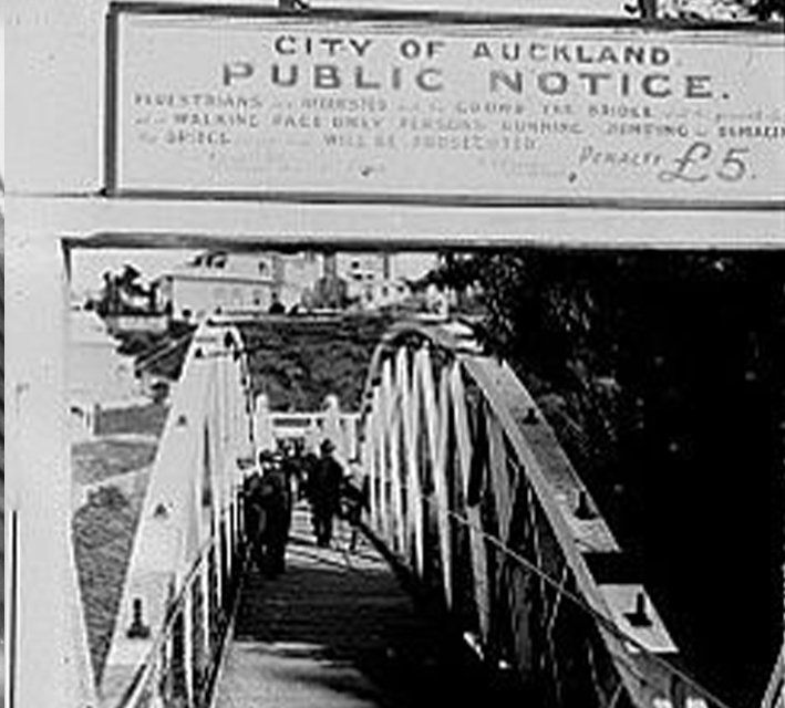
Grafton Bridge
Migrant History
Myers Park
Myers Park Designer
The Beginning

Subscribe to the
Karangahape Road newsletter...
NEWSLETTER
Karangahape Road Business Association © All Rights Reserved 2020
Made by Monster Valley & This Needs Doing
AUCKLAND TRANSPORT JOURNEY PLANNER:
Find out your best route to Karangahape Road by bus, ferry or train.